
BuddhistCatholicContemplativeEvangelicalGeneral ChristianHinduJewishLatter-day SaintMuslimNew VisionsProgressive Christian
Beliefs
- Buddhist
- Catholic
- Contemplative
- Evangelical
- General Christian
- Hindu
- Jewish
- Latter-day Saint
- More Voices
- Muslim
- New Visions
- Pagan
- Progressive Christian
Topics
- Religion News
- Food and Religion
- Sports and Religion
- Religious Art
- Religious Music and Entertainment
- Religious Events
- History and Religion
- Style and Religion
- Politics and Religion
- Women in Religion
- Recreation Outdoors and Religion
- Business Finance and Religion
- Careers Workplace and Religion
- Education and Religion
- Family Parenting and Religion
- Health Fitness and Religion
- Home and Religion
- Relationships and Religion
- Technology and Religion
- Travel and Religion
Columnists
- Buddhist Columnists
- Business Finance and Religion Columnists
- Careers Workplace and Religion Columnists
- Catholic Columnists
- Contemplative Columnists
- Education and Religion Columnists
- Evangelists Columnists
- Family Parenting and Religion Columnists
- General Christian Columnists
- Health Fitness and Religion Columnists
- Hindu Columnists
- History and Religion Columnists
- Home and Religion Columnists
- Jewish Columnists
- More Voices Columnists
- Latter Day Columnists
- Muslim Columnists
- New Visions Columnists
- Nonreligious Columnists
- Pagan Columnists
- Politics and Religion Columnists
- Progressive Columnists
- Recreation Outdoors and Religion Columnists
- Relationships and Religion Columnists
- Religion News Columnists
- Religious Art Columnists
- Religious Events Columnists
- Religious Music and Entertainment Columnists
- Sports and Religion Columnists
- Style and Religion Columnists
- Technology and Religion Columnists
- Travel and Religion Columnists
- Women in Religion Columnists
Resource Library
- 2026 Calendar
- Library of World Religions
- The 100 Most Holy Places on Earth
- Patheos Answers
- Podcasts
- Videos
- Faith Leaders Database
- Anglican Episcopalian
- Bahai
- Baptist
- Buddhism
- Christianity
- Confucianism
- Eastern Orthodoxy
- Hinduism
- Holiness and Pentecostal
- ISKCON
- Islam
- Judaism
- Lutheran
- Methodist
- The Church of Jesus Christ of Latter-day Saints
- New Age
- Paganism
- Presbytarian and Reformed
- Protestantism
- Religion Behind the Scenes
- Roman Catholic
- Scientology
- Shia Islam
- Sikhism
- Sufism
- Sunni Islam
- Taoism
- Zen
- See all religions
Research Tools
 Ad-Free & Subscriber Log-In Subscription Support
Ad-Free & Subscriber Log-In Subscription Support
Follow Patheos 

- Trending:
- Forgiveness
- |
- Marriage
- |
- Consciousness
- |
- Death Penalty
- |
- Election
- |
- Halloween
 Paths Through The Forests
- Home
- About
- Comment Guidelines
- Look & Find
- Holidays, Rituals & History
- Creating Connections
- Cultural Quandaries
- Crafts
- Quiz & Questionnaire
- Guest Posts
- Publications
- Archive Index
- Home
- Pagan
- Cultural Quandaries: Water
Cultural Quandaries: Water
Last updated on: December 19, 2016 at 12:55 am by Rua Lupa
Cultural Quandaries: Water 2016-12-19T00:55:57-04:00 Rua Lupa
Patheos Explore the world's faith through different perspectives on religion and spirituality! Patheos has the views of the prevalent religions and spiritualities of the world.
You may be thinking that this is going to go over water waste in the home or disposable water bottles & their associated companies, but that won’t happen. Those topics have been covered quite thoroughly elsewhere and would suggest looking them up (or follow the provided links) if you’re not familiar with them, because everyone should be aware of those issues. This is about something much much more ingrained that it isn’t even on most people’s radar…
From Drowning To Parched
Do you ever wonder why there are water bans even though there was a recent deluge and flooded basements? Why there are floods and droughts in the same place on the news? What if I told you it was because of us? Yes, we humans are very much responsible for such events, the question you’re likely asking now is “but how is that even possible?” or “you’re just talking about the urban landscape”. I’m talking about a reality on all human inhabited landscape, with the exception of the few areas that are occupied by those-in-the-know.
This being a time of year in Borealis (the Northern Hemisphere) where it gets wetter and hotter, and therefore more likely to have floods and fires, is what makes this subject all the more important to cover now. So that at the end of this article you would be able to take action on your own, to at least some degree, to prevent these environmental catastrophes where you are.
Lets begin with an examination of our surroundings. Those of us familiar with the countryside, take a look at the farmer’s fields; not only are they ploughed (follow link to read Cultural Quandaries: Soils), but are more often than not ploughed with a specific direction in mind, downhill. Those more familiar with towns would recognize their lawns being quite flat, sloping away from the home, the ditches sharp and clear of debris, the sidewalks and streets with storm drains stationed periodically down its length. These the suburban and urbanites would recognize as well with the addition of the sea of pavement and concrete. What do all these have in common? They are intended to rush water out of the area.

Water Runoff on Various Local Landscapes. By Rua Lupa
With such a design two problems arise quite drastically: 1) With all the hard surfaces the water pools and flows and with enough water or a blockage at just the wrong place, creates floods; 2) After the water leaves there is no water left to keep the land hydrated, creating drought. Pretty stark isn’t it? And we’ve been doing this for centuries and beyond centuries; Leaving vast regions looking nothing like it did prior to human settlement for so long that the inhabitants get the impression that that area has always been like that. So much of the planet’s surface has been modified like this that the problem exponentiates; because as you go from the highest part of the region to the lowest, the water rapidly piles up and up creating what is normally referred to as Flash Floods. It is this kind of land design that has brought about a great many deserts. In recent times the those-in-the-know that I’ve referred to before have reversed desertification, large scale, within a decade.
Where is this and how did they do it? The answer to where I will answer a little later. As to how they did it? They held the water on the land.
“But wouldn’t that cause flooding?” I here you say, but they didn’t just do that, the slowed down water was able to be spread out over the land and soak into it – storing most of it underground with the rest remaining as ponds which are good at preventing droughts too (evaporation=clouds! Note that Trees are a Big part in this cloud making process – hence Rain Forests), And they grow fish! This spreading and soaking is something that our human settlements are atrocious at doing. Not just because of the mass drainage infrastructure, but because most every surface is hard and unable to absorb water. Just by making these surfaces permeable would reduce flooding ten fold. But slowing and holding the water in place to let it soak shouldn’t be underestimated, because skipping that would still leave a lot of water pooling and flowing off the area. There are already communities out there as examples of this Hold, Spread and Soak approach. Something Permaculturalists (the-people-in-the-know I’ve been referring to) often do in the form of Swales.
A Swale Solution
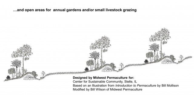
A swale is a ditch that is along contour with the dug up material becoming a loose mound along the down hill side of the ditch. Staggered periodically along these swales are level sill spillways (a level flat stretch that is typically no higher than half-way up the mound so the water gently spills over), this is so that the water doesn’t burst the mounds when there is a lot of water (if it is a short length, just make the ends spillways), and staggered so that the water has to slowly zig-zag along the landscape before it leaves the property – maximizing absorption into the landscape.

Swales Dug. Image Source: Planting Justice
Adding mulch to the ditch helps it absorb more water (any broken up organic matter would work). Using mulch works especially well in dryer areas as it prevents the water from easily evaporating. The mound should be covered with heavy rooted pioneer plants to prevent it from eroding. The mound would then be seeded/planted with perennials, which would include trees (preferably food bearing trees) and support species being nitrogen fixing (podded/legume) & dynamic-accumulator (deep-rooted) plants, ideally having some doubling as pollinator plants. As the mulch breaks down and fills in the swale it can be placed on top of the mound and and new loose mulch debris can be added. In dryer climates the broken down mulch can stay put.
Putting in a swale is something that anybody that can use a shovel can do.
Water always sits level so you can test the level of your swale by pouring a bucket or two of water into it and if it flows in any direction you correct for it so it sits level. You could alternatively do this in the rain for the same results. But there are a couple of tools that make marking out contour easier and is really inexpensive.
A-Frame Level

Boiling Springs, SC Swale Dig. Image Credit: Wendy McCarty
An A-Frame Level is pretty much what it sounds like. You put together three boards or branches into the shape of a capital ‘A’. At the peak you tie on a long string that is weighted so that it hangs straight. Then you stand it as level as you can eye-ball it, mark where the string is then switch where the legs were standing and mark the string again. This should reveal the middle area and in the middle of the two marks make a central mark. Now you are ready to mark contours. All you have to do now is “walk” the A-frame along the property in a way that the string always hangs in the middle. Stake where the legs are as you go along and once you’re done staking the path you dig your swale and spillways.
Water-Tube Level

Water-Tube Level By Rua Lupa
A Water-Tube Level is two poles that are numbered starting one-quarter up the pole to the top; attached to the numbered portion of the poles is a long see-through tube that is filled with water – ideally dyed in order to see it better (I used maple tapping tubes as they are completely clear and thin – using less water (or vinegar with blue food dye in my case to avoid any algae problems), but clear garden hoses work well too). The length of the tubing between the two poles is as far a distance as you wish to measure between stakes and parallel swales (a few meters or yards minimum to allow for optimum movement).
It has the same approach as the A-Frame when finding contours – by “walking” the poles along the contour. The difference being that the starting pole is the baseline and the walking pole is the one that is moved until the two poles have the water level at the same number (If the walking pole is any higher or lower than the contour the water levels would read a lower or higher number than the baseline/starting pole. Then the walking pole just has to be moved up or down the slope until the water is at the same number). Once the walking pole is at the same level as the baseline/starting pole, you stake where it is then the initial starting/baseline pole does the walking and the previous walking pole becomes the new baseline pole.

Water-Tube Level Function. By Rua Lupa
Countryside Approach
Most permaculturalists encounter the following response to the swale suggesstion, “We don’t want to keep water on the land – it’ll drown our crops!” It can be a challenge to explain how the swales and mounds are mitigating the flooding effect while preventing the droughts that just as easily kill crops. What a farm site would end up looking like if designed in a permaculture fashion would have the mounds hosting food bearing trees with support species – preventing erosion and supplying goods at the same time, with the main crops being between the parallel swales – any excess water would be in the swale, not in your crops. Instead of tilled fields though, it would be contour mounds seeded with polycultural species and mulched (if you are a grain farmer you would have a diverse selection of grains and support species growing together; if you are a squash farmer you’d have a diverse selection of squash and support species growing together etc.). The purpose behind having a diverse selection of main crop is to ensure that if the weather is one way, say wet, you’d already have a breed for that as insurance. If the weather ended up being dry, there would already be a breed there that is good for those conditions there for insurance. If a predator to the kind of plant you grow comes around, you’ll likely have a breed that is more resilient to that particular predator. That way you’d always have a successful crop.
Towns & Urban Settlement Approach
In more densely populated areas the only differences in approach is how the transportation infrastructure is put in, having all ground surface areas be permeable, and as many building surface areas as possible vegetated over (green walls/roofs).
The greened building surfaces would slow & clean water, but it would also prevent the “heat-island” effect, making the area much cooler as well as make the air cleaner to breathe. Not to mention a lot more aesthetically pleasing and biodiverse.
Preferably a densely populated area would pre-plan its infrastructure to perform in a water responsible manner, but more likely than not it would have to be redesigning preexisting areas.

Porous Pavement. Image Source: Green Infrastructure Digest
Any new or redesigned roads, bike paths, and side walks would end up being permeable and follow contours with ditches on either side, slowly going up or down hill on contour when necessary. They would periodically have level dips that are equivalent to spillways. When there is a large down pour these spillways would only have a thin layer of shallow water over them – being a non-issue for traversers (this prevents the problem of clogged drainage pipes and is easier maintenance). The down hill side of these routes would be treed mounds that themselves would have level spillways periodically – encouraging the water to slowly zig-zag across the landscape.
Any preexisting traversing infrastructure would have much of the same things established – that being if the route is already reasonably on contour, the ditches, mounds and spillways would be the same. Otherwise the ditches along already establish routes would have stacked stone dams put in heel-toe (where the bottom of the up hill dam would be level with the top of the down hill dam). The edges of these dams would be slightly up hill and embedded into the adjacent earth. The center of the dam would be slightly down hill and lower than the edges. Just below the dam would have a splash pad of stones in the ground to prevent erosion at its base. These stacked stone dams can be made wide enough to be used as pedestrian and cyclist pathways. The roads/paths themselves would periodically have “speed bumps” that would slow the water down and deposit it in the ditches. If done from the highest point in the area to the lowest point, the water would be greatly slowed down and mitigate any flooding potential. It would be advised to start from the top when establishing the stacked stone dams, otherwise it wouldn’t be as effective in preventing floods, but it would still soak water into the ground.

Stack Stone Dams. Image Credit: Rainwater Harvesting for Drylands & Beyond by Brad Lancaster
Some Other Earthworks To Consider
Hugelkultur

Hugelkultur. Image Source: Richsoil.com
Hugelkultur directly translates to “Mound/Hill Culture” in German. It is a ditch filled in with woody debris (preferably not acidic), and the dug soil piled on top of it, seeded with desired garden plants (like you would for a regular garden bed) and mulched. Heavy rooted plants help to quickly stabilize the mound, ideally these would double as nitrogen fixing plants (also called green manure). As the woody debris rots down it becomes more porous and spongy – absorbing water and storing it in the mound which prevents the mound from succumbing to dry conditions. This rot also increases bio-activity within the mound and thus increases biodiversity and resilience against disease. In other words, this is a garden bed that does not require irrigation or fertilizers. The catch is that to get maximum benefits is to build it up to be six feet tall as this is the height that guarantees these effects. But there are some additional beneficial side effects of building to this height, such as, wind break, sound barrier, visual/privacy barrier, not needing to bend down to tend the garden, and gaining more surface area to grow on. If six feet is a bit too tall for your comfort a two feet tall mound is able to hold moisture for about three weeks. An alternative approach is to start out with a two and a half feet tall mound and each year build the size of the bed a foot. So a few years later you’ll have bigger beds and the neighbors wouldn’t really notice. The width of the bed can be determined by your reach, whatever height you decide. Built along a contour creates the same effects as a swale system – the difference only being that the mound has woody debris in it.
Tree Pits/Crescents

Tree Pit. Image Credit: Patricia H. Waterfall, Harvesting Rainwater for Landscape Use
When growing a tree in a dry area it is immensely beneficial to try to catch and hold as much water as possible for your tree when it does rain. In a flatter area or on a small property you can grow your tree in a small pit so that the water pools right where its needed and soaks into that spot. In an area with more slope you can have crescent mounds on the downhill side of your tree for the same effect.

Tree Crescent Swale. Image Credit: Patricia H. Waterfall, Harvesting Rainwater for Landscape Use
Rain Gardens
A rain garden is a pit placed where water would drain into it (i.e. Downspout, ditch drain, or off of any compact/impermeable surface such as parking lots) that is filled with highly permeable debris and is planted with water loving plants.

Rain Garden. Image Credit: Jenny L. at thepleatedzucchini.com
(Addendum May 26/2014, 2pm)
Contour Stone Lines
A contour stone line is pretty well the exact same thing as a swale, but it is used instead when there isn’t much earth to move around. If it is possible, you dig a trench on contour and fill it with large rocks, tightly packed together and smaller rocks piled on the downhill side of the larger stones.

Image Source: Youtube: Climate Change Adaptation technology: Stone Lines by International Institute For Environment & Development.
If there are a lot of large rocks available and/or not really any soil, you can make a “bund” which is a tall long pile of rocks! – on contour.

Bund
So it just goes to show that no matter what environment you are in you can make a difference.
Examples of How Far This Can Go
As for the large scale reversed desertification I mentioned earlier, here is the amazing documentary that shows how The Loess Plateau in China went from a barren exhausted desert to a large oasis as well as other similar stories in Africa, South America and the Middle East.
Previous Post
May 22, 2014
A New Look at the Magic of Trees
Next Post

May 28, 2014 Wordless Wednesday: The call of summer
Browse Our Archives
Select a Category Crafts Creating Connections Cultural Quandaries Earth Matters Earthly Rites Ecopsychology Fur and Feather Guest Posts Look & Find Natural Reflections Nature in the News Nature-based Holidays Nearby Nature Permaculture Quiz & Questionnaire Rituals & Ceremonies Science & Spirit The Sacred in Suburbia Uncategorized Wordless Wednesday
Select a Month January 2017 December 2016 November 2016 October 2016 September 2016 August 2016 June 2016 April 2016 March 2016 February 2016 January 2016 December 2015 November 2015 October 2015 September 2015 August 2015 July 2015 June 2015 May 2015 April 2015 March 2015 February 2015 January 2015 December 2014 November 2014 October 2014 September 2014 August 2014 July 2014 June 2014 May 2014 April 2014 March 2014 February 2014 January 2014 December 2013 November 2013 October 2013 September 2013 August 2013 July 2013 June 2013 May 2013 April 2013 March 2013 February 2013 January 2013 December 2012 November 2012 October 2012 September 2012 August 2012 July 2012 June 2012 May 2012 April 2012 March 2012 February 2012 January 2012 December 2011 November 2011
Follow Us!
TAKE THE
Religious Wisdom Quiz
How many books in the Bible are named after women?
Select your answer to see how you score.
10 1 2 5
Related posts from Paths Through The Forests

The Paradox of Tolerance Led To Fascism In...

Coalition Urges Facebook To Be Transparent About Censorship,...


Saegoah Pursuits: Creative Eco-Friendly Gift Wrapping
TRENDING AT PATHEOS Pagan

I was recently chatting with someone on Instagram. She asked me what...

While there are many people who share their results, the end of...

On July 23, I saw Christopher Nolan's The Odyssey which is Homer’s...

As I write this two big events have just finished up. One...

Restoring the Watershed of Divine Love
Perhaps cooperation is not something we manufacture through legislation, ideology, or moral...

Many UUs don’t pray because of bad experiences in a previous religion,...
view all Pagan blogs
Ad-Free & Subscriber Log-In Subscription Support
- About Us
- 2026 Calendar
- Videos
- Podcasts
- Library of World Religions
- Faith In Media Tracker
- Advertise With Us
- Write for Us
- Privacy Policy
- Terms of Service
- Do Not Sell My Data
- Contact Us
- Radiant Digital
- Manage Newsletter Subscriptions
- Unsubscribe From Notifications
- Sitemap
Copyright 2008-2026, Patheos. All rights reserved.
Subscription Support Ad-Free & Subscriber Log-In
Follow Patheos